Oxford's open spaces
Oxford’s magnificent and widely varied open spaces, formal and informal, are threatened by the pressure to build housing and expand the city’s universities.

|
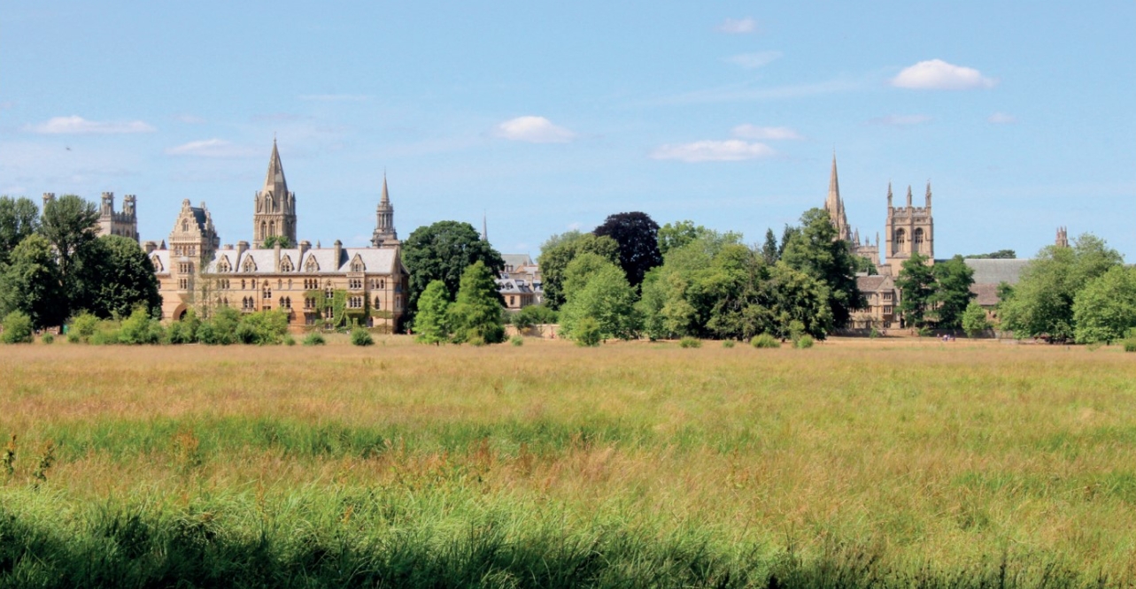
| Christ Church Meadow, where the Rivers Thames and Cherwell meet (Photo: Grayswoodsurrey, Wikimedia). |
In 2012, the university gained planning approval for a number of four-and-five storey blocks on the edge of Port Meadow, Oxford’s oldest and largest protected space. The modern designs and white paint, coinciding with a chance pruning of nearby willows, made them stand out from the other side of Oxford. A planning row ensued which led the university to spend an additional £5 million to change the shape and appearance of the six buildings. This bruising event highlights one aspect of Oxford’s view of its open spaces: an opportunity to have uncluttered views of the centre. These are enshrined in viewing cones which are formally protected in Oxford’s plan. Generally the centre is best seen from the hills surrounding Oxford, but development has mostly been managed to respect the views of spires and towers of the city centre. This is only one aspect of the open spaces threading through Oxford and for which residents are grateful and protective.
With a population of 154,000, the city is surrounded by a ring road which can be used as a convenient perimeter; it mostly is surrounded by its floodplain and coincides with the city boundary. Oxford’s open spaces, not all publicly accessible, mostly surround the two rivers that flow through the city: the Thames and the Cherwell, meeting not far from the centre. The Cherwell valley is surrounded by rough grazing on its east side and college land on much of the west. Although there are a number of footpaths, the main navigation of the Cherwell is by punt. The meeting of the two rivers is in Christchurch meadow, a beautiful area which houses most of the Oxford college boathouses. During a normal summer this will be home to rowing contests, while for the rest of the year, a towpath on one side of the Thames (here called the Isis) and shady walks the college side are enjoyed by many. The meadow is private land and closed at night. One side, overlooked by various colleges, hosts playing fields. The other provides rough grazing, a popular circular walk and magnificent, mature trees.
Following the Thames north again, through dense urban areas towards Port Meadow, leads to Oxford’s other flood plain and largest open space. Port Meadow, a 120-hectare common owned by the city, connects to Wolvercote Common at its north end and Burgess Field on the eastern side, once Oxford’s very own waste dump, now replanted and successfully operating as a wild space, close to the heart of the town. Port Meadow floods regularly both in winter (much used for skating) and summer, providing storage space for water coming down the Thames. Due south of here the city has gradually built over the flood plain, leaving many homes vulnerable. The latest (currently stalled) proposal is a £150 million flood channel along the western outskirts of the city through pasture land. Not everyone appreciates having their land compulsorily purchased, although many homeowners would like the extra protection.
Cattle, horses and geese graze in apparent harmony along Port Meadow. The famed black poplars line the bank of the Thames here. The Meadow has never been ploughed and has evidence of its many uses over the last millennia: bronze-age barrows, parliamentary fortifications, a military aerodrome and, less obviously, raves and horse races.
Scattered around the town are 22 allotment sites, most of which are owned by the city. Many have waiting lists.
Sports grounds are still very prominent around the city, thanks to the universities. Many university colleges have historically had their own grounds, usually set some way away from the college. These have proved costly to maintain and some are merging their facilities. At the time of writing many sports grounds have been totally unused for six months and are still maintained as pristine swards inaccessible to the public. Some are proving attractive for a new development interest: building accommodation for junior staff, for example young research students who may find it difficult to come to Oxford without this support. With housing so expensive (Oxford has the highest ratio of property prices to earnings of any UK city), the local plan is encouraging this kind of development.
There are a number of wild spaces within the built up areas of the town which have been fought over by local people. The Trap Grounds is a small piece of land lying between the Oxford Canal and the railway line. It was suggested as a town green and then as a site for development by the city council. After a House of Lords appeal it was agreed that it should be protected, and it is now a greatly valued local wildlife site and town green covering 10 acres of reedbed and woodland.
Access to the Trap Grounds is from the towpath of the Oxford Canal. This runs from the centre of town to the Grand Union (once a short cut to get midlands coal to London) and is in normal times well used both as a residence for canal-boat dwellers and visitors who use the terminal in Jericho where boats can be hired. It also serves as a valuable walking and cycle route north now that the tow path is metalled. The canal meets the Thames on its way, and there is a vision to build a canal basin at the end of the canal in what is currently a car park. Whether this ever comes to pass will depend on the college owners of the land and the city council. It is probably still a long way off.
Warneford Meadow is another site of community challenge. The Warneford, the posh one of Oxford’s two mental health facilities, acquired 20 acres which it wanted to use to generate capital for the hospital. This was challenged by residents, who applied to register the site as a town green at the beginning of this century. The case went to the high court and was upheld. These small jewels of sites need to be seen in the wider context of the city’s many beautiful parks. Perhaps the jewel in the crown is the University Park, which covers 30 hectares. Bordered by the Cherwell on one side, it hosts a splendid collection of mature trees planted from 1865 as an arboretum. It hosts the university cricket ground in its centre and ‘parsons pleasure’, where dons used to sunbathe naked. It is a private space, closed at night and closed to cycles, whose main route it straddles.
Much more open are the city’s main parks of South Park and Headingtonhill Park. South Park is mostly 50 acres of open space with great views of the city. It is much used by the city as the location of the annual fireworks display and for concerts. It now has Oxford’s own distillery at its north end, making gin using botanicals from the Botanic Garden.
Adjacent to South Park on the other side of the London road is a small park connected to South Park by a high-level pedestrian bridge. It surrounds Headington Hill Hall, once home of the Morel family and more famously of Robert Maxwell. A part of the land is left as a public park, well planted with all manner of unusual trees. The park is now owned by the city. Other smaller parks, council owned and supported by friends groups, include Sunnymead Park, running along the Cherwell and containing playgrounds, and much recent tree planting; Bury Knowle Park, seven hectares running alongside the London road and with a full suite of plantings, sculptures and activities; and Florence Park in east Oxford, again very busy, whose 10 hectares include a repurposed children’s centre. In 2016 the council undertook a survey of green spaces. Although the precise method is not clear, it identified 67 spaces across Oxford, of which half lay within the ring road, and the rest nearby.
Oxford is surrounded by green belt to limit development. This has succeeded to a point. Large areas beyond the ring road were developed in the 1970s to the south and east. Now Oxford faces government demands to build an additional 10,800 homes over the 20-year plan period. The plan talks of higher densities and heights, and new locations. For the most part these involve using existing sites better. Although they should not impinge on the defined open spaces, inevitably there will be a sense that there is more building and less space surrounding existing buildings. Large areas of land immediately adjacent to the ring road but outside it are being developed or proposed for development. These will particularly affect the connection with Kidlington in the north, drawn by the recent railway station lying between Oxford and Kidlington.
A number of campaigns over the years have defended open spaces. Residents’ groups, easily able to draw in both planning skills and resources, have had successes in defending local sites. In the case of the Castle Mill development by the university, campaign groups caused the university to take major mitigating steps to reduce the development’s impact. The case of the flood relief channel is supported by the flood relief alliance, made up of those living especially in the Botley Road area, liable to flooding, and harried by landowners on the route, including the Oxford Preservation Trust.
The green belt has been prized open for house building. The local plan protects most open spaces, but flooding is probably the most effective means of protection. The pressures on the council to build new houses, the further relaxation of planning restrictions and the possibility of flood control all pose threats to Oxford’s fabulous open spaces. The university and its colleges constitute a further threat. They own large tracts of land and are determined to expand to ensure that Oxford remains one of the world’s leading universities. University College is seeking to create a new campus in the middle of the Victorian suburb conservation area; St John’s College is turning green fields into a large business and residential area on the edges of Oxford (called Oxford North), which will create huge pressures of traffic, which happens to converge close to the site. And the golf course, beloved of some, looks to be being prepared for housing, which will effectively link Oxford and Kidlington, something the green belt was attempting to stop. With friends like these, Oxford needs all the flooding it can manage.
Driven by a determination to expand the two universities in Oxford, the city is becoming like a pressure cooker. With jobs located mostly in the centre, the radial routes into Oxford are increasingly unable to cope with the volume of transport. New housing on the periphery will only increase this pressure until new forms of rapid transit are available.
This article originally appeared as ‘Open spaces under threat’ in Context 166, published by the Institute of Historic Building Conservation (IHBC) in November 2020. It was written by Sam Clarke, a semi-retired Oxford resident of 40 years, recently chair of a suburban neighbourhood plan, and an enthusiastic environmentalist and tree planter.
--Institute of Historic Building Conservation
Related articles on Designing Buildings Wiki
- Congestion in historic cities.
- Conservation officers in historic towns.
- Conservation.
- Conserving the Hilda Besse Building.
- Heritage.
- IHBC articles.
- Institute of Historic Building Conservation.
- Intensifying development in Oxford.
- Oxford Castle.
- Oxford College Gardens and Cambridge College Gardens.
- Oxford Movement.
- Oxford: adapt, change and grow.
- Reorganising and conserving Oxford's Mitre site.
- The consequences of planning reform for Oxford.
- The voluntary sector and the planning of Oxford.
IHBC NewsBlog
Latest IHBC Issue of Context features Roofing
Articles range from slate to pitched roofs, and carbon impact to solar generation to roofscapes.
Three reasons not to demolish Edinburgh’s Argyle House
Should 'Edinburgh's ugliest building' be saved?
IHBC’s 2025 Parliamentary Briefing...from Crafts in Crisis to Rubbish Retrofit
IHBC launches research-led ‘5 Commitments to Help Heritage Skills in Conservation’
How RDSAP 10.2 impacts EPC assessments in traditional buildings
Energy performance certificates (EPCs) tell us how energy efficient our buildings are, but the way these certificates are generated has changed.
700-year-old church tower suspended 45ft
The London church is part of a 'never seen before feat of engineering'.
The historic Old War Office (OWO) has undergone a remarkable transformation
The Grade II* listed neo-Baroque landmark in central London is an example of adaptive reuse in architecture, where heritage meets modern sophistication.
West Midlands Heritage Careers Fair 2025
Join the West Midlands Historic Buildings Trust on 13 October 2025, from 10.00am.
Former carpark and shopping centre to be transformed into new homes
Transformation to be a UK first.
Canada is losing its churches…
Can communities afford to let that happen?
131 derelict buildings recorded in Dublin city
It has increased 80% in the past four years.


