Intensifying development in Oxford
After a long history of restriction, a new approach to planning reflects a belief that in the right places tall buildings might make positive contributions to the city’s skyline.

|
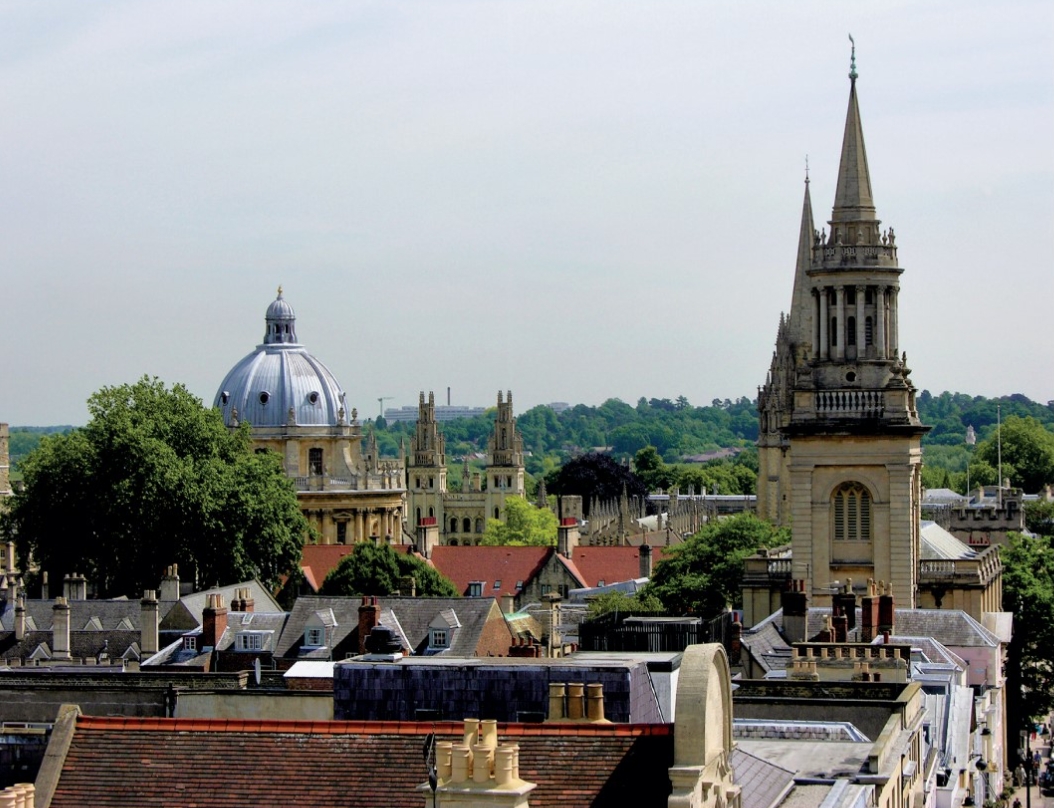
| A view from Carfax Tower, including Radcliffe Camera, All Souls and Lincoln Library spire. |
Oxford’s distinctive skyline has been captured in words and images for many centuries. It is acknowledged locally, nationally and internationally as a valuable asset for the city and something that it is important to protect.
This significance was first really identified as needing to be protected through planning policy in 1962 when the first high buildings and view-cones policy was written and adopted by the city council. The aim was to protect the important views of the city, seen from its surrounding open countryside, from the then post-war demands for housing and other development. This policy, in an adapted form, is still very much used today as the basis for understanding the important viewpoints around the city from where the skyline can be seen and appreciated.
As part of the raft of measures available to protect the ‘dreaming spires’, the city council adopted as part of its local plan a policy measure named ‘the Carfax Rule’ for the surviving tower of St Martin’s Church, which sits at the historic crossroads at the centre of the city and therefore importantly within the group of historic towers and spires that makes up the skyline. The previous (2001–16) local plan policy was tight, stating that ‘planning permission will not be granted for any development within a 1,200-metre radius of Carfax that exceeds 18.2m (60ft) in height or ordnance datum (height above sea level) 79.3m (260ft) (whichever is the lower), except for minor elements of no great bulk.’ While this version of the policy has been extremely effective in protecting the historic skyline, it has left no room for nuance. In some cases it has restricted height where it might be considered to have no harmful impact on views of the skyline and would be a positive addition to the city’s built heritage.
Subsequently, a Study of Oxford in its Landscape Setting, undertaken in 2002, identified 16 viewpoints, and in 2015, in collaboration with the Oxford Preservation Trust and Historic England, the Oxford View Cones Study was undertaken to provide a more quantifiable methodology for the assessment of impact on the skyline. The study included but also extended the number of viewpoints from those identified in 1962. It states that the viewpoints are intended to be only a sample, to which other identified views, both from the green countryside surroundings and from within the city, may be added. The findings of the study, including the methods used and advised, have underpinned local plan policies since their completion. They are an important tool in informing and understanding the impact of new developments on the skyline.
The most recent version of the tall buildings policy is more versatile, opening up the possibility of new positive contributions to the skyline. This has been a controversial change, and the question as to whether new elements might be appropriately added to what is an iconic profile is complicated. However, the original group, identified in the verses of Matthew Arnold or the illustrations of JMW Turner, is not of a single form, profile, age or indeed architectural style, but rather a group of very different spires, domes and towers constructed at different periods in history, from St George’s Tower (1071) to the copper-clad ziggurat of the Saïd Business School (2001). Nothing unifies them apart from the fact that they rise above the ‘grey beauty’ or ‘base and brickish skirt’ in views from the surrounding countryside where people walk and have observed the city over centuries.
Oxford is a relatively small city, hemmed in by its rivers, the Thames and Cherwell, and surrounded by green hills. From many places within the city it is possible to glimpse the surrounding countryside: this is one of its absolute delights. Expanding from its walled medieval core, the city has absorbed a number of the surrounding stone-clad settlements, such as Headington, Marston and Wolvercote. By virtue of an acknowledged balance between local resident and authority controls, these settlements have managed to preserve their sense of place.
In some cases the open spaces in between have survived as riparian meadows along the Cherwell or Thames, such as the historic commons of Port Meadow, a large area of grassland to the north-west of the city that has been used for grazing since the bronze age, or South Park, an open green space given to the people of Oxford by the Oxford Preservation Trust in 1951. These vital spaces give generously those moments at dawn and dusk when the spires and towers of the city emerge from the gentle mist, or glow in the receding evening light with all the accompanying sounds.
The boundaries of the city are tight. Much of its surrounding countryside, including city suburbs, are controlled by others to whom the city must trust their protection against the tide of houses destined to become the homes of families working in the city. Space for development, particularly housing, within the city’s boundary is at a premium. Pressures come from the universities for student and staff accommodation and from the ever-increasing number of spin-off or research-and-development companies.
Looking at the present character of the city’s residential suburbs, relatively low-rise housing, and sensing the pressures on the individual colleges and universities to improve their facilities, the city’s planners began to consider tall buildings. Would it be possible to make good places for people with beautiful spaces around them without harming the skyline? The topography meant that building not very high in certain places would be substantially harmful to other places. It might, however, be possible to increase densities, building up with medium-density housing surrounded by exciting outdoor spaces, and not impact on the important views of the ‘dreaming spires’ or out from the city to its amphitheatre of surrounding hills.
Working with a local landscape architecture practice and engaging local stakeholders, the city council developed a policy supported by a technical advice note (TAN) for high buildings. Neither the TAN nor the policies that it supports seek to be prescriptive. The purpose is to establish a method that can be applied to each case to establish the impact that a design would have on important and protected views. The document is intended as a tool for positive, iterative design, based on an understanding of the impact of a design with regard to a building’s height, mass and appearance.
The TAN carefully avoids defining ‘high’, explaining that it will be entirely dependent on context. The document shows how layers of information can be built up to inform decisions as to where it may be possible to increase building heights in parts of the city without impacting on the characteristics that it is important to preserve. The evidenced-based report that sits behind the TAN builds on the work of earlier studies, including the View Cones Study of 2015, and takes into account other policies within the local plan, including the Carfax policy. The report also identified important views out of and within the city, exploring methods of analysing the impact of taller buildings. The TAN sets out those methods with worked examples and begins to identify areas of the city that might be suitable for taller buildings. Encouragement is given to developers to engage with the process at the earliest stage of design development.
A number of projects that have been through this process are under construction. It will be interesting to see how comfortably they sit in their context.
This article originally appeared in Context 166, published by the Institute of Historic Building Conservation (IHBC) in November 2020. It was written by Gill Butter, an architect and a principal heritage officer at Oxford City Council.
--Institute of Historic Building Conservation
Related articles on Designing Buildings
- Congestion in historic cities.
- Conservation officers in historic towns.
- Conservation.
- Conserving the Hilda Besse Building.
- Heritage.
- IHBC articles.
- IHBC-SAHGB announce 2021 annual research award winner.
- Institute of Historic Building Conservation.
- Oxford Castle
- Oxford Movement.
- Oxford: adapt, change and grow.
- Reorganising and conserving Oxford's Mitre site.
- The consequences of planning reform for Oxford.
- The voluntary sector and the planning of Oxford.
IHBC NewsBlog
Latest IHBC Issue of Context features Roofing
Articles range from slate to pitched roofs, and carbon impact to solar generation to roofscapes.
Three reasons not to demolish Edinburgh’s Argyle House
Should 'Edinburgh's ugliest building' be saved?
IHBC’s 2025 Parliamentary Briefing...from Crafts in Crisis to Rubbish Retrofit
IHBC launches research-led ‘5 Commitments to Help Heritage Skills in Conservation’
How RDSAP 10.2 impacts EPC assessments in traditional buildings
Energy performance certificates (EPCs) tell us how energy efficient our buildings are, but the way these certificates are generated has changed.
700-year-old church tower suspended 45ft
The London church is part of a 'never seen before feat of engineering'.
The historic Old War Office (OWO) has undergone a remarkable transformation
The Grade II* listed neo-Baroque landmark in central London is an example of adaptive reuse in architecture, where heritage meets modern sophistication.
West Midlands Heritage Careers Fair 2025
Join the West Midlands Historic Buildings Trust on 13 October 2025, from 10.00am.
Former carpark and shopping centre to be transformed into new homes
Transformation to be a UK first.
Canada is losing its churches…
Can communities afford to let that happen?
131 derelict buildings recorded in Dublin city
It has increased 80% in the past four years.


