Orford Ness: resolving a landscape in conflict
Taking care of Orford Ness depends on appreciating the order in disorder and the beauty in ugliness: savouring its attractions and persuading others to fall in love with it.

|
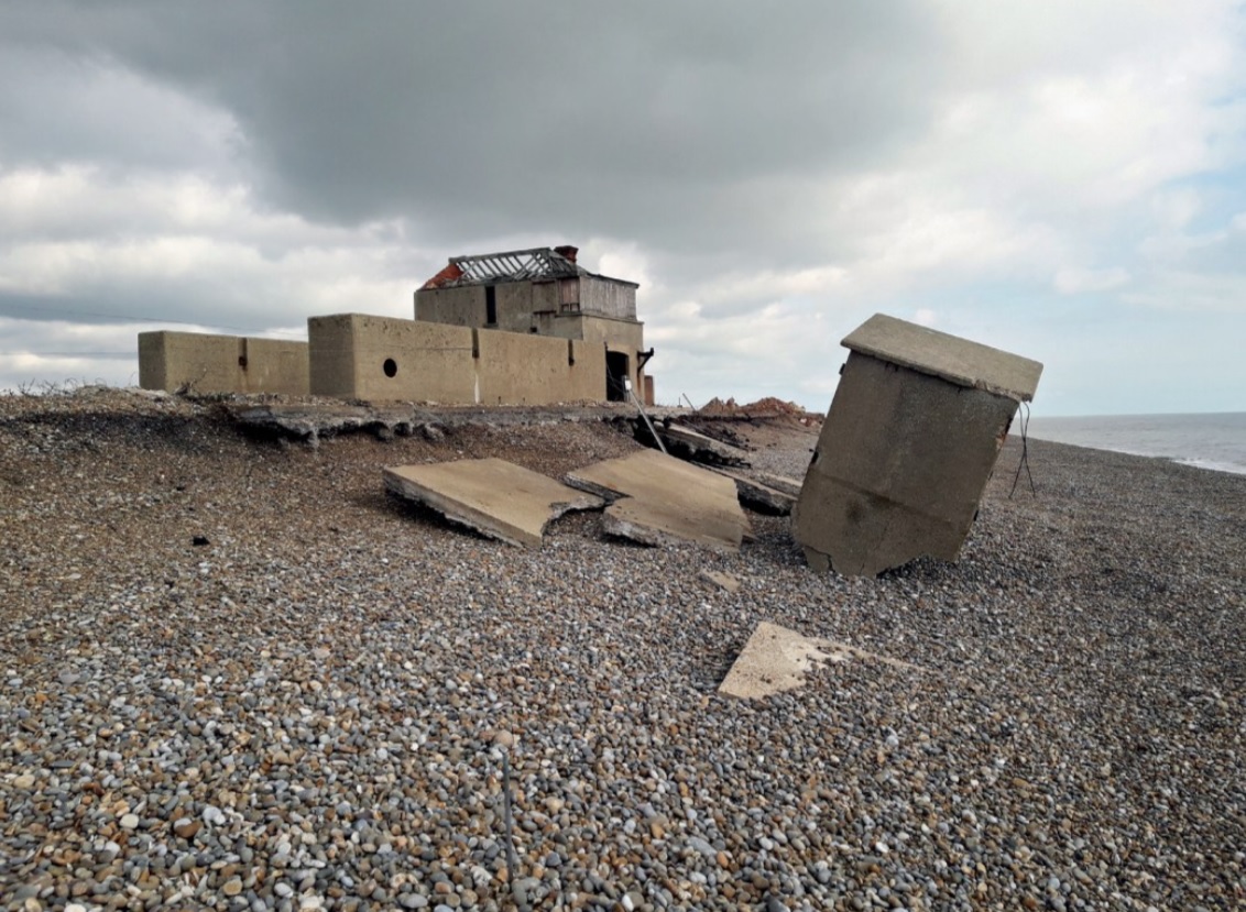
| The coastguard lookout and some military installations about to swept away (Photo: National Trust). |
Orford Ness lies on the eastern edge of England. Its vegetated shingle spit, the largest in Europe, stretches for 16 kilometres south of Aldeburgh in Suffolk. Behind it is a thin strip of grazing marsh and mud flat, then the River Ore divides the spit from the mainland and the village of Orford, still dominated by its medieval castle. The importance of its geology and biology, reflected in its many national and international designations, led the National Trust to acquire Orford Ness in 1993. But for the visitor, its long history of military experimentation is more striking. The landscape is dominated by the structures and detritus of decades of intense scientific activity.
Many who visit Orford Ness dislike it at first, including many decision-makers within the National Trust. Around the time of its acquisition many in the trust believed that the place should be ‘tidied up’ and converted back to a ‘wilderness’. This was the reaction of those used to judging the charms of lowland farms or elegant landscape parks. As the new curators, our job was to step beyond such institutional reactions and to understand Orford Ness on its own terms, to appreciate the order in disorder and the beauty in ugliness. We had to listen to its stories, learn to savour its attractions and finally persuade others to fall in love with it. This article summarises how we did this.
The military connection began in 1915 when the Royal Flying Corps bought the site as a research station. During 1935–6, Robert Watson-Watt’s team began work here on the development of Radar, demonstrating its possibilities as a practical air-defence system before moving to a larger site nearby. This achievement came just in time to allow Radar to take a pivotal role during the Battle of Britain. During the second world war, experimental work focused on bomb ballistics trials on a purpose-built bombing range.
The site was handed over to the Atomic Weapons Research Establishment in 1959, when the cold war threatened to turn into a hot war on such a scale that whole nations could be destroyed. Enormous concrete laboratories were built on the shingle to carry out environmental tests on the atomic bomb, designed to mimic the rigours which a weapon might suffer before detonation. They included vibration, extremes of temperature, shocks and so on. Although the weapons did not contain radioactive material, the high-explosive initiator was present. A test failure might result in catastrophe, so the laboratories were designed to absorb and dissipate an explosion.
What will be the memorials to the turbulent decades of the later 20th century? In earlier periods, defensive buildings were used both strategically and for show, to display power against real or imagined threats. A classic example is Orford Castle, built by Henry II to counterbalance the power of local barons. But by the end of the second world war, ostentatious buildings had been made redundant by the vast destructive power of new weaponry, and from then on, power was displayed by parading technology in public. Redundant weapons are preserved in museums, but these will never have the hold on the imagination that the great medieval castles do.
Much of the appeal of these structures stems from the contrast between the dominating scale of the architecture and the effects of time on their fabric. Some castles can still hold us in awe, especially where their imposing form is set in opposition to the forces of nature, such as at Dunstanburgh on the windswept Northumbrian coast. The impact of this castle in its landscape is comparable with that of the AWRE test cells standing in the shingle wastes at Orford Ness.
The decaying cold-war buildings at Orford Ness show our continuing confrontation with the forces of nature, which over time can erode or destroy our structures. In the harsh environment of the Ness, the destructive powers of nature are evident in the massive shingle banks thrown up or scoured away, sometimes in a single day. Since 1993 three buildings have disappeared into the sea, and one has collapsed in a storm. In 2020 the famous lighthouse (not owned by the National Trust) was demolished before it too could be swept away.
Defining the aesthetic, symbolic and historical importance of the buildings was the first step in the production of a management plan. The next step was to identify the features which contribute most to these. They were summarised, along with nature conservation aspects, in a statement of significance which defined the key features the trust should preserve.
When describing Orford Ness, one tends to use adjectives such as bleak, mysterious, secret or hostile. Although these words describe the overriding impression of the shingle areas, they do not fit other parts of the property. Just as one might define different habitat areas, and develop different management prescriptions for each, it was important to try to define areas with different aesthetic characteristics. Orford Ness can be divided into character areas, which gain their distinctiveness from their geology and past history and management. There is not space here to describe all the character areas, but to illustrate the contrasts I will describe one briefly before going into more depth on another.
The Airfield Marsh, the first area seen by the visitor after alighting from the boat, initially seems a piece of unspectacular pasture. This feeling is created by the high riverbanks, which cut off any views, and by the arrangement of dilapidated military buildings around grazed fields. Despite their appearance, some of these buildings are especially significant, either for rarity (for example, the first-world-war barracks) or for their historical associations (for example, Watson Watt’s Radar research building). Both of these are now listed. The visitor then crosses a bridge over a creek to the shingle spit, home of the Atomic Weapons Research Establishment (AWRE) during the cold war.
The disposition and unusual shapes of the AWRE buildings and the flat, almost featureless, desert landscape they inhabit lead to a disturbing difficulty in judging distances. During the long walks between the buildings their monumental scale begins to be appreciated, and as they loom larger, anticipation grows; this slow process is one of the attractions of the place. The scale of the buildings is overbearing, and in this exposed landscape the individual can feel overpowered in their presence.
Once a building is reached, the sense of mystery increases. What are now silent, shadowy, rubble-strewn and roofless interiors give little clue to what were once the home of banks of humming machinery and white-coated technicians. Secrecy is strongly implied by the deliberate obliteration of any evidence of function and by the heavy metal grilles that keep out the visitor. The areas between the buildings are scattered with debris; close inspection reveals the concrete and iron to be disintegrating under attack from salt spray and the colonising plants and lichens.
I have described some of the aesthetic qualities at length because they had a controversial effect on the management plan for the site. Familiarity with the site led to a realisation that the curation of the processes of decay and colonisation of man-made structures by nature should be one of the key actions in the plan. This was difficult for conservation professionals, who normally try to halt or slow these processes, not to work with them.
Following analysis of the aesthetic qualities, a general philosophy of non-intervention or curated decay was adopted. The challenge is how to both preserve the evidence of the past use of the site and allow natural processes to run their course. The philosophy will be applied differently in different character areas, varying due both to practical constraints and to a parallel management aim to enhance the natural history value of the property.
Legislation plays a constraining part too, as during the development of our philosophy some buildings gained statutory designation. The AWRE buildings are now scheduled monuments, a designation that allows for the progress of natural processes, while other buildings are listed, which means that the National Trust must maintain them in good condition.
Over the years we have realised that our original character areas needed to be more nuanced. This, together with the intersection of legislation, public access, and conflict between heritage and nature values, led us to realise that the old management plan was too broad-brush. It needed to be expanded and deepened, in the form of a conservation management plan written by a National Trust team in collaboration with our consultants Purcell. One recommendation was that buildings in the curated decay zone were losing structural detail and should consequently be recorded – a project that will start this year.
The National Trust’s formal name is the National Trust for Places of Historic Interest or Natural Beauty. That Orford Ness is historically interesting can not be disputed, but is it beautiful? If awe and drama are part of natural beauty, and if man-made structures make a contribution, then Orford Ness is beautiful. Not far away the National Trust helps preserve a timeless rural landscape immortalised by the painter John Constable. At Orford Ness it looks after a landscape of stark contrasts symbolic of the real and current concerns of our time. Although these landscapes are so different, understanding and managing their aesthetic qualities is equally challenging.
Further reading
Heazell, Paddy (2013) Most Secret: the hidden history of Orford Ness, History Press.
This article originally appeared in the Institute of Historic Building Conservation’s (IHBC’s) Context 175, published in March 2023. It was written by Angus Wainwright, the National Trust archaeologist in East Anglia since 1995. His role covers all aspects of archaeology from atomic weapons research facilities to bronze-age burial mounds.
--Institute of Historic Building Conservation
Related articles on Designing Buildings
IHBC NewsBlog
Latest IHBC Issue of Context features Roofing
Articles range from slate to pitched roofs, and carbon impact to solar generation to roofscapes.
Three reasons not to demolish Edinburgh’s Argyle House
Should 'Edinburgh's ugliest building' be saved?
IHBC’s 2025 Parliamentary Briefing...from Crafts in Crisis to Rubbish Retrofit
IHBC launches research-led ‘5 Commitments to Help Heritage Skills in Conservation’
How RDSAP 10.2 impacts EPC assessments in traditional buildings
Energy performance certificates (EPCs) tell us how energy efficient our buildings are, but the way these certificates are generated has changed.
700-year-old church tower suspended 45ft
The London church is part of a 'never seen before feat of engineering'.
The historic Old War Office (OWO) has undergone a remarkable transformation
The Grade II* listed neo-Baroque landmark in central London is an example of adaptive reuse in architecture, where heritage meets modern sophistication.
West Midlands Heritage Careers Fair 2025
Join the West Midlands Historic Buildings Trust on 13 October 2025, from 10.00am.
Former carpark and shopping centre to be transformed into new homes
Transformation to be a UK first.
Canada is losing its churches…
Can communities afford to let that happen?
131 derelict buildings recorded in Dublin city
It has increased 80% in the past four years.


Comments
[edit] To make a comment about this article, click 'Add a comment' above. Separate your comments from any existing comments by inserting a horizontal line.