Location and civil engineers
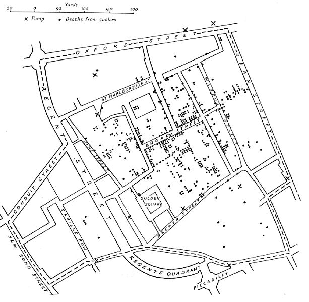
A variant of the original map drawn by Dr. John Snow (1813-1858), a British physician who is one of the founders of medical epidemiology, showing cases of cholera in the London epidemics of 1854, clustered around the locations of water pumps.
Contents |
[edit] Introduction
Engineers of all disciplines need Geographic Information Systems (GIS) for the very simple reason that geospatial data makes projects faster, better, and more cost effective.
[edit] History
One of the first pieces of Geographic Information Systems (GIS) analysis was performed amidst an outbreak of cholera in London’s Soho district in 1854. The transmission mechanism for the disease was unknown at the time, so the evidence to investigate was constrained to the people who had fallen ill.
John Snow, an early epidemiologist was the first recorded person to treat this data as spatial data. He interviewed residents to understand key interactions with local environmental factors, including water pumps in the area. He put patients on a map and undertook Voronoi analysis [a spatial pattern technique] to draw a link between a single water pump and the illness, and further substantiated his findings by showing an anomaly; nearby brewery workers who should have been falling ill at the same rate were spared by their daily beer allowance, which enabled them to avoid the problem pump.
His findings are commonly cited within health geography, but rarely enter an engineering syllabus, despite his further geospatial work comparing practices of various waterwork engineering companies.
The key learning point for engineers is that if Snow had been working with merely a list of patients, he would have had no opportunity to link that list with the deadly water pump and it could have remained a medical mystery and a worsening tragedy. So where else can geospatial data uncover hidden value?
[edit] Finding a context
Whether you deal in utility networks, transportation, energy production or telecoms, your project has a location (grid coordinate, depth, height), or perhaps even a moving location, which is even more important to manage well. When an object has a location, it allows you to discover, explore, analyse and interact with its context of multiple, delicate interdependencies on built and natural environmental elements both inside and external to the project elements themselves. This might be demography, geomorphology, utility grid issues, flood forecasting, mobile phone pings of a moving population, bat records, the list goes on.
Manage these diverse elements poorly and you’ll find your project blocked at planning, poorly used once complete, inefficient to operate or perhaps just really difficult at end-of-life disposal stage. Multi-discipline project teams will come to loggerheads over mutually exclusive design decisions, construction teams will despair over how to implement environmental mitigation, and valuable information will be obfuscated at every data exchange point.
GIS (Geographic Information Systems) is of course only one tool to prevent this kind of chaos, but it’s a very important one, and one that’s frequently overlooked or seen as a competitor rather than a colleague or player within other data management systems such as BIM. Given that the big software houses on both sides are becoming increasingly intertwined, here are a few ways engineers can interact with GIS and implement it in workflows;
[edit] Layered insight
Due to the diversity of elements within the environmental context of a project, GIS is frequently the only solution which can examine them all within a single system by looking at their sole unifying factor - their location. GIS can instantly count how many trees with bat potential sit within 20km of a site or calculate the population that would suffer power outages in the event of substations flooding. It can calculate energy use baselines for a whole town on the journey to net zero, or identify every viewpoint impacted by development of a new road. Adding layers of data enables powerful analysis to be carried out.
[edit] Automating to unlock insights
GIS really lends itself to automation, via integration with sophisticated Python data libraries such as NumPy and SciPy, as well as the use of licensed tools such as FME. Using these tools allows GIS specialists to build reusable tools for iterative analysis and data processing tasks ranging from multi-sheet compulsory purchase order drawings for infrastructure development to networking tasks for water utilities.
By using multiple data sources, these insights can be updated based on changes in the surrounding area - not just changes within a project. Having an iterative source of insight into these outside changes will enable engineers to easily pinpoint and manage risk from externalities providing a more realistic view.
[edit] Crack your data management
Many of the burgeoning document management systems, such as Projectwise, don’t yet handle spatial data files well. However GIS as a sector has adapted to this technological drawback by building new links between systems to facilitate better cross-project data management.
A Spatial Common Data Environment, as we have developed at Atkins, provides a single-source-of-truth for spatial data, with visualisation tools such as 3D and 2D WebGIS already built in, to give a whole-project window for the full team. Using automated versioning, GIS can automatically allow design fixes to be shared with multi-disciplinary teams within, for example, a development consent order (DCO) process, helping to get deliverables done on time and with minimal rework.
[edit] GI-Yes for Engineers – a match made in data?
Atkins recently won accolades for their work in geospatial led design, where geospatial data on environmental constraints was considered first before a single engineer got to work. The resulting linear infrastructure centre line options handed to its civil engineers achieved the maximum avoidance of environmental, heritage and socioeconomic assets, speeding up delivery and reducing costs dramatically.
There is more data available than ever and ripe for GIS use. As our industries continue to develop digital processes, we will all need to use as much data as we can lay our hands on, and geospatial consultants alongside engineers can be the ideal partnership to ensure this happens.
This article originally appeared on the ICE Civil Engineer Blog under the title "Why it’s all about location, location, location for civil engineers". It was written by Elspeth McIntyre PIEMA, AMICE, Geospatial Consultant, Atkins and published on 1 July 2020.
--The Institution of Civil Engineers
[edit] Related articles on Designing Buildings Wiki
Featured articles and news
Building Safety recap January, 2026
What we missed at the end of last year, and at the start of this...
National Apprenticeship Week 2026, 9-15 Feb
Shining a light on the positive impacts for businesses, their apprentices and the wider economy alike.
Applications and benefits of acoustic flooring
From commercial to retail.
From solid to sprung and ribbed to raised.
Strengthening industry collaboration in Hong Kong
Hong Kong Institute of Construction and The Chartered Institute of Building sign Memorandum of Understanding.
A detailed description fron the experts at Cornish Lime.
IHBC planning for growth with corporate plan development
Grow with the Institute by volunteering and CP25 consultation.
Connecting ambition and action for designers and specifiers.
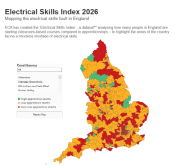
Electrical skills gap deepens as apprenticeship starts fall despite surging demand says ECA.
Built environment bodies deepen joint action on EDI
B.E.Inclusive initiative agree next phase of joint equity, diversity and inclusion (EDI) action plan.
Recognising culture as key to sustainable economic growth
Creative UK Provocation paper: Culture as Growth Infrastructure.
Futurebuild and UK Construction Week London Unite
Creating the UK’s Built Environment Super Event and over 25 other key partnerships.
Welsh and Scottish 2026 elections
Manifestos for the built environment for upcoming same May day elections.
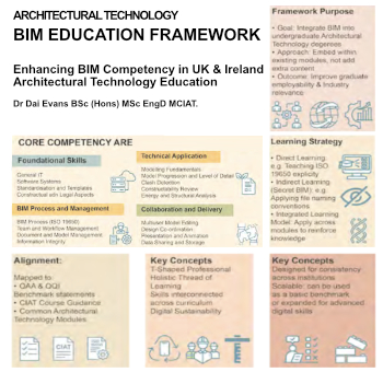
Advancing BIM education with a competency framework
“We don’t need people who can just draw in 3D. We need people who can think in data.”
Guidance notes to prepare for April ERA changes
From the Electrical Contractors' Association Employee Relations team.
Significant changes to be seen from the new ERA in 2026 and 2027, starting on 6 April 2026.
First aid in the modern workplace with St John Ambulance.
Solar panels, pitched roofs and risk of fire spread
60% increase in solar panel fires prompts tests and installation warnings.
Modernising heat networks with Heat interface unit
Why HIUs hold the key to efficiency upgrades.


