The history of Southend-on-Sea
One of the country’s newest cities, the resort of Southend-on-Sea in Essex has a history that can be charted through its conservation areas, many of them with a seaside setting.

|
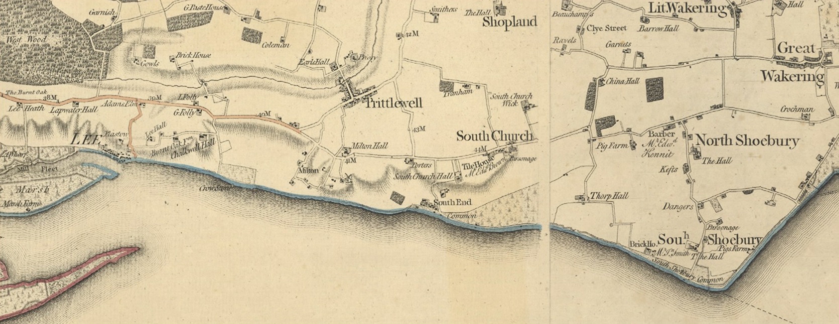
| Part of Chapman and André’s Map of Essex, 1777, showing the once-dispersed settlement pattern (Tim Fransen, 2018, Digital Map of the County of Essex 1777 by John Chapman and Peter André). |
From the Saxon settlement of Prittlewell to 20th-century housing developments, the history of Southend-on-Sea can be charted through its conservation areas. Almost all of the 15 conservation areas in Southend have a visual and functional relationship with the sea and coastline. This is one of their vital characteristics that significantly contributes to their special interest.
The Prittlewell Conservation Area contains some of the oldest buildings in Southend. Prittlewell was established as a village in the Saxon period and later thrived during medieval times, becoming one of the primary settlements in south-east Essex and the principal village in the immediate area which has today become Southend. A minster church was built there in the 7th century, with parts of an arch from this period still surviving in the medieval St Mary’s Church. Nos 255 and 269–273 Victoria Avenue remain as examples of timber-framed buildings from the 15th and 16th centuries.
As can be seen on Chapman and André’s Map of Essex from 1777, Prittlewell was the largest of the settlements in the vicinity, with South End a small collection of buildings on the shoreline. The settlement was first recorded as ‘Stratende’ in 1309, becoming ‘Southend’ by the 18th century. It remained a very small farming district until around 1700 when it was discovered that the foreshore was an excellent breeding ground for oysters, an industry that lasted until the early 20th century. With this discovery, and the growth of the London barge trade, the settlement began to expand.
Meanwhile to the west, the village of Leigh (Lee on Chapman and André’s map) developed as an important port in south-east Essex and a centre for boatbuilding. This is now designated as the Leigh Old Town Conservation Area; its intimate, narrow, cobbled streets lend an atmosphere of age despite many of its buildings being from the 19th century onwards.
From the mid-18th century Southend began to develop a different role as local landowners tried to exploit the new fashion of sea-bathing for health benefits. Initially, the modest resort catered mostly for local gentry. By the 1790s it was attracting people from London via new stagecoach services, with a concerted effort made to create a more exclusive and fashionable resort to rival those established at Margate, Brighton and Weymouth. The Clifftown Conservation Area covers this Georgian development of Southend. The Royal Terrace was developed by landowner Daniel Scratton as the first part of ‘New South End’. However, from the outset and despite royal visitors (Royal Terrace was so named after Princess Caroline visited in 1804), the resort initially failed to attract the fashionable society intended. The coming of the railway in 1856 turned the fortunes of the resort around, with Scratton leasing out further land to railway developer Peto, Brassey and Betts to develop the Cliff Town Estate. Strict design controls on the first phase of development have left us today with a unified series of terraced housing laid out around pleasant open spaces and gardens.
‘Old South End’ to the east was developed as the more commercial part of the resort, which gained its first pier in 1833. The pier had been extended by 1848 to become the longest pleasure pier in the world. The fishing and maritime trade functions of Southend continued alongside the developing resort at this time, characterised by the small weatherboarded cottages dating from the early-19th century, facing the seafront in the Eastern Esplanade Conservation Area. New attractions on the seafront were developed for visitors, along with new hotels and guesthouses, including the vast Hotel Metropole (now the Palace Hotel) adjacent to the pier, built in 1901 (now in the Clifftown Conservation Area). The grand amusement park of the Kursaal, designated as another of the conservation areas, was built in 1890. It originally contained a dining hall, theatre, concert and dancing hall, bar, arcade, hippodrome and menagerie.
The seafront promenade was laid out and new housing spread over the surrounding area. Several of Southend’s conservation areas reflect residential growth in this period, including Warrior Square, Milton, The Leas, Crowstone, Leigh and Leigh Cliff, all characterised by late Victorian and Edwardian housing and shops. The newly designated Hamlet Court Road Conservation Area also demonstrates an up-market commercial high street that developed to serve residents away from the original resort centre.
The Chapmanslord Conservation Area is a distinctive conservation area that reflects a different style of early-20th-century housing development; it was created by the Chapmanslord Housing Society as ‘homes fit for heroes’ following the Housing Act 1919. It was designed on the principles of the garden city movement, with houses in an arts-and-crafts cottage style set back in leafy gardens, with generous tree and shrub planting on the streets.
The dispersed villages once dotted along the coastline are now joined into one settlement through the rapid expansion of built development in the late 19th and early 20th centuries, from Leigh to the west to Shoebury to the east. Here, the Shoebury Garrison Conservation Area covers the military base established in the 1840s next to the sea front, built in a unified style and materials, with the detail and quality of the architecture reflecting the status of the use or user.
The coastal setting influences the essential character of the different conservation areas, such as in Leigh Old Town, which is set much closer to the water’s edge and has areas that are industrial in nature, with boats moored in the marina. The sea provides the visual context to the conservation areas, forming a wide, flat stretch of blue in views out to the south, with expansive skies above. Built development is oriented towards the sea, with streets running down towards the sea or cliff front, creating channelled views between buildings. Views were even planned in the development of Clifftown, where diagonally set roads meant that every property was supposed to have a sea view (although in reality this is not the case in the streets set further back).
The setting of many properties high up on the cliff front, and the creation of the promenades and several public gardens along the coastline, also enable people to appreciate the seaside setting. In other conservation areas, whether the small fishermen’s cottages of Eastern Esplanade or the grand villas and terraces in The Leas and Clifftown, houses face the sea, and often take advantage of the views with balconies and large windows.
Sounds, smells and the weather are also important factors in creating the setting and sense of place. There are particularly distinctive sensory elements associated with the sea that are evident in Southend. These include the sound of sea birds, waves, amusements arcades and the metallic click of masts and halyards in the wind. The smell of salt water and the sight of boats or the smell of fish where the fishmongers spread out their wares at the cockle sheds in Leigh Old Town all contribute to the character of the conservation areas and help to define their setting. Even blustery coastal winds or a bright sunny day where people come out to enjoy the weather affect the character and activity within and in the setting of coastal conservation areas.
Over the last three years Southend-on-Sea’s 15 conservation areas have benefitted from the completion or updating of conservation area appraisals. The setting of each of the areas is defined in the appraisals and the documents provide updated assessments of their special interest, and management guidance. These appraisals will help to ensure that the heritage values of Southend’s conservation areas are protected through informed decision making in the planning process, and that their important coastal setting and character are preserved.
This article originally appeared as ‘Southend-on-Sea: from seaside village to city’ in the Institute of Historic Building Conservation’s (IHBC’s) Context 175, published in March 2023. It was written by Sally Humphries, a senior heritage consultant at Purcell, the heritage consultants, architects and master planners who have prepared the conservation area appraisals on behalf of Southend-on-Sea City Council.
--Institute of Historic Building Conservation
Related articles on Designing Buildings
IHBC NewsBlog
Latest IHBC Issue of Context features Roofing
Articles range from slate to pitched roofs, and carbon impact to solar generation to roofscapes.
Three reasons not to demolish Edinburgh’s Argyle House
Should 'Edinburgh's ugliest building' be saved?
IHBC’s 2025 Parliamentary Briefing...from Crafts in Crisis to Rubbish Retrofit
IHBC launches research-led ‘5 Commitments to Help Heritage Skills in Conservation’
How RDSAP 10.2 impacts EPC assessments in traditional buildings
Energy performance certificates (EPCs) tell us how energy efficient our buildings are, but the way these certificates are generated has changed.
700-year-old church tower suspended 45ft
The London church is part of a 'never seen before feat of engineering'.
The historic Old War Office (OWO) has undergone a remarkable transformation
The Grade II* listed neo-Baroque landmark in central London is an example of adaptive reuse in architecture, where heritage meets modern sophistication.
West Midlands Heritage Careers Fair 2025
Join the West Midlands Historic Buildings Trust on 13 October 2025, from 10.00am.
Former carpark and shopping centre to be transformed into new homes
Transformation to be a UK first.
Canada is losing its churches…
Can communities afford to let that happen?
131 derelict buildings recorded in Dublin city
It has increased 80% in the past four years.


