Urban fringe
The urban fringe is a distinct type of countryside, whose often surprising and sometimes strange sense of place deserves to be celebrated and helped to evolve.

|
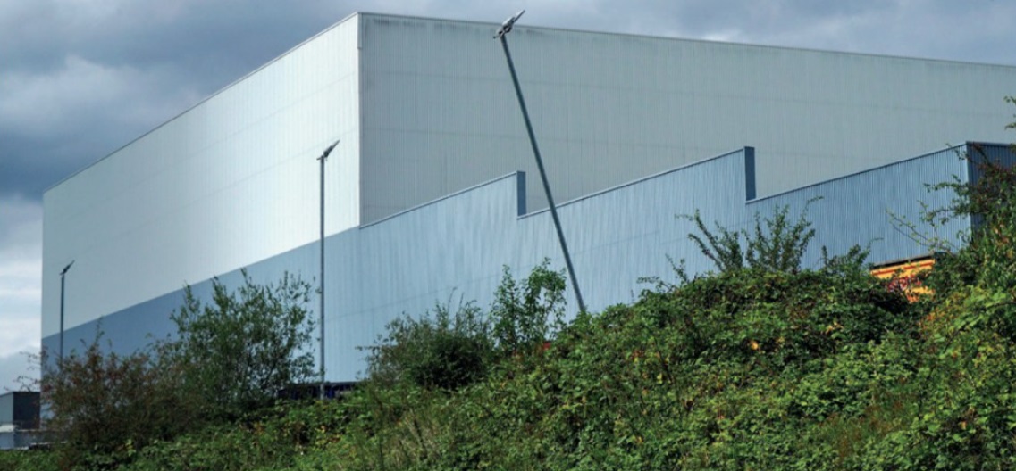
| Wincanton Group warehouse at National Distribution Park, Whitacre. |
The urban fringe is an untidy place: neither completely urban nor entirely rural. The sewage treatment works stands next to the distribution park, the trading estate pushes into farmland, birdsong competes with the clatter of shunting freight wagons. Exploring the fringe means negotiating concrete and tarmac, palisade fencing with Keep Out notices and rank vegetation.
But this fringe environment has long been a literary landscape. In 1973 Richard Mabey celebrated the wildlife of the outer reaches of London in The Unofficial Countryside. Psychogeographer Iain Sinclair completed a walk around the M25 in the last days of the 1990s, publishing his sometimes outspoken impressions as London Orbital. Poets Paul Farley and Michael Symmons Roberts explored ‘England’s last true wilderness’ in their book Edgelands, published in 2011. In Outskirts (2017) architectural writer John Grindrod charts the history of the green belt in which he grew up. Close to the places that form the main focus of this article, Lynsey Hanley drew on the experience of her early life in the large local authority housing estate of Chelmsley Wood in Estates (2007) and Respectable (2016).
Whitacre Heath is about 10 miles north-east of the centre of Birmingham. For train commuters from the east, it marks the point where the train slows a little on the journey towards the city or gathers speed for the return journey through the north Warwickshire countryside. The railway passes through the valley formed by the River Tame and its tributaries the Blythe and the Cole. The elegant hilltop spire of the church of St Peter and St Paul Coleshill is a common landmark for drivers and rail passengers through the eastern edges of Birmingham. Northward from here the valley of the Tame is a patchwork of lakes in old gravel workings.
Birmingham has been extending its influence over Whitacre since the second half of the 19th century. Shustoke Reservoir, just to the east, was built in the 1880s. Nearby is Whitacre Waterworks, built in 1872 to the design of Chamberlain and Martin (favoured architects to the unrelated Joseph Chamberlain). This is a monumental example of Birmingham’s civic architecture placed in a rural setting. Built in Ruskin-influenced Venetian gothic, the waterworks has a tall central hall, with rose windows and turrets, that forms a powerful landmark beside the railway.
Across the tracks, and in complete contrast, is Peggs Barn. The barn is a medieval box-frame cottage that looks like a relic from the landscape familiar to George Eliot (Mary Ann Evans), born at Arbury Hall near Nuneaton in 1819. That impression would be right, but its story has an extra layer of interest. The barn was dismantled in 1985 at its site at Daw Mill Colliery, about 1.5 miles to the south east, and moved to Whitacre Heath as a community building project managed by Coleshill and District Civic Society. It served as a scout hut until 2008 when it was sold for residential use.[1]
Near Peggs Barn, a patch of woodland, donated by a local benefactor and managed by the parish council, forms part of a matrix of habitats that interlaces with the built element of the landscape in the way described by Richard Mabey. Train passengers through Whitacre can glimpse herons, buzzards, little egrets and tufted ducks or, for the particularly sharp-eyed, a kingfisher, particularly at the confluence of the Cole and Blythe rivers. Electricity pylons, signature urban-fringe structures, provide nesting opportunities for peregrines.
Whitacre and Coleshill are at a nodal point in the national motorway network; the intersection of the M6, M6 Toll and M42: and the landscape is shaped by transport infrastructure. The central geographical position offers the maximum reach within a lorry driver’s time limits for a working day. This makes the area a key location for the distribution park. For Farley and Symmonds Roberts these are tranquil places favoured by driving instructors for early lessons. But the complexes of huge boxes, in colours matching the sky or woodland, are dramatic landscape features: for some an ugly intrusion, or a giant abstract artwork, or both.
The town of Coleshill, about a mile south of Whitacre, was a coaching stop on the road from London to Chester. It still retains elements of the time before it was bypassed in the 1830s by the Holyhead Road through Birmingham and the Black Country.
Across the valley of the River Cole, to the west of the town, Coleshill Park was the home of the Wingfield-Digby family. Gatehouse towers from the earlier house, scarred by civil war artillery, were excavated as part of the archaeological dig preceding the construction of HS2, along the eastern edge of the park. A large ornamental garden was also excavated and the excavations were featured on the BBC’s Digging for Britain.
The Wingfield-Digbys built a new house to the north of the historic site in 1872–73, commissioning John Middleton of Cheltenham as architect. Historic maps and photographs show the estate in pristine countryside and the road to Birmingham as a tree-lined country lane. But by the early 20th century the family had left for its other estates and the house began to come within the force field of the city.
By 1912 Coleshill Park had become a retreat house for the Birmingham Anglican Diocese. Then for 60 years from about 1930 it was used as a mental hospital serving Birmingham, its grounds colonised by wards and residential blocks. Now the site stands on an island formed by motorways and HS2. Its seemingly uncongenial location is suited to its current use as a commercial office park. Lynsey Hanley’s Chelmsley Wood estate is just to the south across the M6.
This picture of the urban fringe, with its mix of buildings, land uses and infrastructure, is not unique to east Birmingham. Similar places will be familiar to many readers. But is the urban fringe important?
George Eliot’s novel Middlemarch is generally considered to be a portrait of society in Coventry, where Eliot lived for part of her life, in the years around 1830. It was a period of intellectual, social and political change in which Eliot was much engaged. It was also a time of change from a rural to an urban, industrial economy, exemplified by the projects and technological optimism of Eliot’s fictional surveyor Caleb Garth. The urban fringe, gradually and patchily changing from rural to urban, is going through a similar process in our own time.
The fringe accounts for a huge amount of land around our cities. Growing numbers of people live in its towns, villages and estates. It is an important place for recreation: walking and cycling, fishing, bird watching and botanising. Many thousands of people pass daily through the urban fringe on their commute, or on longer journeys by rail and motorway. The industrial estates, distribution parks and transport infrastructure are essential components of the national economy. The reservoirs and sewage disposal works of the urban fringe helped to make the development of modern life in cities possible.
Positive change in the urban fringe could come from responses to current concerns. In Ockendon, Essex, a 70-hectare refuse tip is being developed as a solar farm. The Woodland Trust plans to plant 50 million trees around cities across England in a belt from Liverpool to Hull, in an initiative which could transform the fringes of northern cities.
As John Grindrod shows, parts of the urban fringe are protected by green-belt status. But the process of change in the fringe is driven partly by the need for land for housing, and even the green belt is under pressure. Writers like Sinclair, Farley and Symmonds Roberts present a picture of distinct places rather than a characterless intermediate zone between other places. Coleshill and Whitacre show the layered evidence of gradual change, partly driven by the influence of Birmingham and by national communications. The unexpected shapes and abrupt juxtapositions, the mixture of very diverse building types, and the patchwork of water, vegetation and hard surfaces, all serve to make a place of real interest in itself and one which illustrates important aspects of national history.
The urban fringe is not as celebrated as areas of outstanding natural beauty or national parks. Nor does it form part of the country’s image of itself as more obviously picturesque landscapes do. But it is a type of countryside. A recognition and understanding of its peculiar character could be a start in devising planning and design policies that enable the fringe to evolve in ways that retain something of its own, often surprising and sometimes strange, sense of place.
[1] The author is grateful to Jennifer Leadbetter, Heritage and Conservation Officer with North Warwickshire Borough Council, for this information.
This article originally appeared as ‘Fringe benefits’ in the Institute of Historic Building Conservation’s (IHBC’s) Context 178, published in December 2023. It was written by Michael Taylor, editorial coordinator for Context and a former rail commuter through the eastern Birmingham urban fringe.
--Institute of Historic Building Conservation
Related articles on Designing Buildings
IHBC NewsBlog
Latest IHBC Issue of Context features Roofing
Articles range from slate to pitched roofs, and carbon impact to solar generation to roofscapes.
Three reasons not to demolish Edinburgh’s Argyle House
Should 'Edinburgh's ugliest building' be saved?
IHBC’s 2025 Parliamentary Briefing...from Crafts in Crisis to Rubbish Retrofit
IHBC launches research-led ‘5 Commitments to Help Heritage Skills in Conservation’
How RDSAP 10.2 impacts EPC assessments in traditional buildings
Energy performance certificates (EPCs) tell us how energy efficient our buildings are, but the way these certificates are generated has changed.
700-year-old church tower suspended 45ft
The London church is part of a 'never seen before feat of engineering'.
The historic Old War Office (OWO) has undergone a remarkable transformation
The Grade II* listed neo-Baroque landmark in central London is an example of adaptive reuse in architecture, where heritage meets modern sophistication.
West Midlands Heritage Careers Fair 2025
Join the West Midlands Historic Buildings Trust on 13 October 2025, from 10.00am.
Former carpark and shopping centre to be transformed into new homes
Transformation to be a UK first.
Canada is losing its churches…
Can communities afford to let that happen?
131 derelict buildings recorded in Dublin city
It has increased 80% in the past four years.


