Spatial diagram
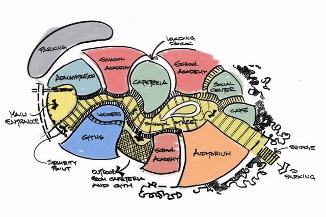
A spatial diagram, or spatial plan, can be used to investigate or illustrate the future spatial development of an area. It communicates a development concept as physical spatial elements and demonstrates how extending and developing spatial uses and infrastructure can shape a location, district or region.
The development of spatial diagrams requires imaginative and innovative ideas. Inspiration for developing a spatial diagram is often drawn from the results of other district or regional analysis methods.
A spatial diagram may give indications as to the highest priority areas to be developed, as well as decisions on the settlement pattern for development in the future. Approximate scales are used for the diagram in order to avoid committing to detail. More specific land use plans are developed once a decision has been taken to implement certain elements of a diagram.
A spatial diagram is not constrained by time, but is designed to be a flexible model, capable of providing guidance and information to urban planners and decision-makers in optimising investment. Such investment can encourage and enable economic and social development, and may result in the progressive delivery of the spatial diagram over time.
Investment decisions are often taken, particularly effecting urban centres, with consideration of functional specialisation to avoid too much competition and duplication, which can lead to a decline in markets or services. Spatial diagrams can be used to assist in this planning work, with what is termed a 'settlement pattern'. This indicates issues such as whether or not the economies of the main urban centres are to be further developed or consolidated, whether urban specialisation should be either maintained or encouraged, and so on.
As well as the settlement pattern, information that is often provided on a spatial diagram may include:
- Road networks.
- The land use system.
- Conservation areas.
- Areas where development is to be restricted or controlled.
Some of the benefits of using a spatial diagram include:
- It is a useful method for reviewing proposed development policies and how they may interrelate functionally with ‘space’.
- It provides a framework for guiding an area’s development.
- It can coordinate development activities undertaken by different planning institutions, organisations or departments.
- It can provide guidance to decision-makers and planners about strategic investment decisions.
Some of the limitations of using a spatial diagram include:
- Spatial diagrams do not contain a time line for development.
- The costs and resource mobilisation required are not illustrated, and so, unless previous analytical steps, such as demographic projections and locational evaluations, have been undertaken, the diagram can be misleading.
- There is the risk that spatial diagrams can be interpreted as masterplans, rather than just being used to guide development decisions.
[edit] Related articles on Designing Buildings Wiki
Featured articles and news
A case study and a warning to would-be developers
Creating four dwellings... after half a century of doing this job, why, oh why, is it so difficult?
Reform of the fire engineering profession
Fire Engineers Advisory Panel: Authoritative Statement, reactions and next steps.
Restoration and renewal of the Palace of Westminster
A complex project of cultural significance from full decant to EMI, opportunities and a potential a way forward.
Apprenticeships and the responsibility we share
Perspectives from the CIOB President as National Apprentice Week comes to a close.
The first line of defence against rain, wind and snow.
Building Safety recap January, 2026
What we missed at the end of last year, and at the start of this...
National Apprenticeship Week 2026, 9-15 Feb
Shining a light on the positive impacts for businesses, their apprentices and the wider economy alike.
Applications and benefits of acoustic flooring
From commercial to retail.
From solid to sprung and ribbed to raised.
Strengthening industry collaboration in Hong Kong
Hong Kong Institute of Construction and The Chartered Institute of Building sign Memorandum of Understanding.
A detailed description from the experts at Cornish Lime.
IHBC planning for growth with corporate plan development
Grow with the Institute by volunteering and CP25 consultation.
Connecting ambition and action for designers and specifiers.
Electrical skills gap deepens as apprenticeship starts fall despite surging demand says ECA.
Built environment bodies deepen joint action on EDI
B.E.Inclusive initiative agree next phase of joint equity, diversity and inclusion (EDI) action plan.
Recognising culture as key to sustainable economic growth
Creative UK Provocation paper: Culture as Growth Infrastructure.


