


Spatial diagram

A spatial diagram, or spatial plan, can be used to investigate or illustrate the future spatial development of an area. It communicates a development concept as physical spatial elements and demonstrates how extending and developing spatial uses and infrastructure can shape a location, district or region.
The development of spatial diagrams requires imaginative and innovative ideas. Inspiration for developing a spatial diagram is often drawn from the results of other district or regional analysis methods.
A spatial diagram may give indications as to the highest priority areas to be developed, as well as decisions on the settlement pattern for development in the future. Approximate scales are used for the diagram in order to avoid committing to detail. More specific land use plans are developed once a decision has been taken to implement certain elements of a diagram.
A spatial diagram is not constrained by time, but is designed to be a flexible model, capable of providing guidance and information to urban planners and decision-makers in optimising investment. Such investment can encourage and enable economic and social development, and may result in the progressive delivery of the spatial diagram over time.
Investment decisions are often taken, particularly effecting urban centres, with consideration of functional specialisation to avoid too much competition and duplication, which can lead to a decline in markets or services. Spatial diagrams can be used to assist in this planning work, with what is termed a 'settlement pattern'. This indicates issues such as whether or not the economies of the main urban centres are to be further developed or consolidated, whether urban specialisation should be either maintained or encouraged, and so on.
As well as the settlement pattern, information that is often provided on a spatial diagram may include:
- Road networks.
- The land use system.
- Conservation areas.
- Areas where development is to be restricted or controlled.
Some of the benefits of using a spatial diagram include:
- It is a useful method for reviewing proposed development policies and how they may interrelate functionally with ‘space’.
- It provides a framework for guiding an area’s development.
- It can coordinate development activities undertaken by different planning institutions, organisations or departments.
- It can provide guidance to decision-makers and planners about strategic investment decisions.
Some of the limitations of using a spatial diagram include:
- Spatial diagrams do not contain a time line for development.
- The costs and resource mobilisation required are not illustrated, and so, unless previous analytical steps, such as demographic projections and locational evaluations, have been undertaken, the diagram can be misleading.
- There is the risk that spatial diagrams can be interpreted as masterplans, rather than just being used to guide development decisions.
[edit] Related articles on Designing Buildings Wiki
Featured articles and news
International Electrician Day, 10 June 2025

Celebrating the role of electrical engineers from André-Marie Amperè, today and for the future.
New guide for clients launched at Houses of Parliament

'There has never been a more important time for clients to step up and ...ask the right questions'
The impact of recycled slate tiles

Innovation across the decades.
EPC changes for existing buildings

Changes and their context as the new RdSAP methodology comes into use from 15 June.
Skills England publishes Sector skills needs assessments

Priority areas relating to the built environment highlighted and described in brief.
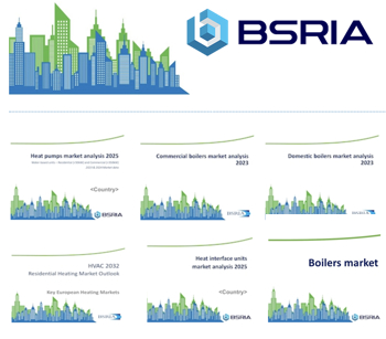
BSRIA HVAC Market Watch - May 2025 Edition
Heat Pump Market Outlook: Policy, Performance & Refrigerant Trends for 2025–2028.
Committing to EDI in construction with CIOB

Built Environment professional bodies deepen commitment to EDI with two new signatories: CIAT and CICES.
Government Grenfell progress report at a glance
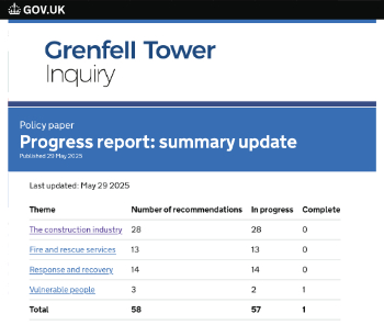
Line by line recomendation overview, with links to more details.

An engaging and lively review of his professional life.
Sustainable heating for listed buildings

A problem that needs to be approached intelligently.
50th Golden anniversary ECA Edmundson apprentice award
![]()
Deadline for entries has been extended to Friday 27 June, so don't miss out!
CIAT at the London Festival of Architecture
![]()
Designing for Everyone: Breaking Barriers in Inclusive Architecture.
Mixed reactions to apprenticeship and skills reform 2025

A 'welcome shift' for some and a 'backwards step' for others.
Licensing construction in the UK

As the latest report and proposal to licence builders reaches Parliament.
Building Safety Alliance golden thread guidance
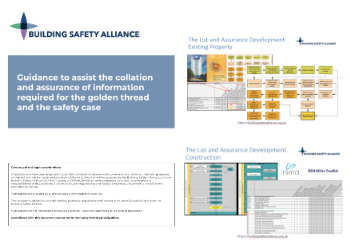
Extensive excel checklist of information with guidance document freely accessible.
Fair Payment Code and other payment initiatives

For fair and late payments, need to work together to add value.
Pre-planning delivery programmes and delay penalties

Proposed for housebuilders in government reform: Speeding Up Build Out.
High street health: converting a building for healthcare uses

The benefits of health centres acting as new anchor sites in the high street.