


Site plan

Contents |
[edit] What is a site plan?
A site plan is typically a large scale drawing that shows the full extent of the site for an existing or proposed development. Site plans, along with location plans, may be necessary for planning applications. In most cases, site plans will be drawn up following a series of desk-based studies and site investigations.
See also: Location plan.
[edit] What scale should a site plan be?
Depending on the size and complexity of the project, site plans are likely to be at a scale of 1:500 or 1:200. However, for very small projects, larger scales may be used, and for large projects smaller scales, or even several drawings may be required, perhaps pulled together on one very small scale plan.
[edit] What should a site plan include?
The information shown on a site plan will vary depending on the nature of the project, however, certain key information is likely to appear on most site plans:
- Title block, giving the project name, drawing type, author, revision number, status, date, the scale used, and so on.
- Notes highlighting changes from previous revisions.
- Directional orientation. This could be a compass or a north-pointing arrow.
- Key dimensions.
- Key materials.
- Site boundaries and delineation of adjacent properties, including where necessary, adjoining or adjacent structures, and surrounding streets.
- The location of the building, buildings or other built assets (such as bridges, tunnels and so on) in relation to their surroundings.
- Trees, tree protection orders, and the main elements of the landscape.
- Parking areas with dimensions or capacities, traffic flows, and signage.
- Roads, footpaths, ramps, paved areas, and so on.
- Easements such as right-of-ways, right of support, and so on.
- Buildings to be demolished or removed.
- The general extent of earthworks, including, cutting and filling, the provision of retaining walls, and so on.
- The general layout of external services, including drainage, water, gas, electricity, telephone, manhole covers, and so on.
- The layout of external lighting.
- Fencing, walls and gates.
- The location of miscellaneous external components such as; bollards, fire hydrants, signage, litter bins, and so on.
Where the site is complex, some of this information might be shown on additional specialist site plans, such as; structural site plans, site history, site lines, services site plans, landscape drawings, access and traffic flows, ground conditions and geology, and so on. Site plans may be accompanied by site sections, showing the topography of the site.
With the adoption of building information modelling (BIM), site plans are likely to form an integral part of the project information model and may be prepared in 3D, perhaps based on a point cloud survey or as light detection and ranging (LIDAR, a combination of the words ‘light’ and ‘radar’).
Site plans might be prepared for both the existing site and the proposed site, and sometimes for intermediate stages if the development is to be phased, or where it is necessary to show information about the phasing of construction works.
See also: Site layout plan for construction.
[edit] Related articles on Designing Buildings
- 3D laser survey.
- As-built drawings and record drawings.
- Block plan.
- Concept drawing.
- Condition survey.
- Development appraisal.
- Elevations.
- Ground conditions.
- Laser scanning.
- Levelling.
- Location plan.
- Pre-construction information.
- Scale drawing.
- Site appraisals.
- Site information.
- Site layout plan for construction.
- Site survey.
- Soil survey.
- Surveyor.
- Types of drawings for building design.
[edit] External references
Featured articles and news
The UK's Modern Industrial Strategy: A 10 year plan

Previous consultation criticism, current key elements and general support with some persisting reservations.
Building Safety Regulator reforms

New roles, new staff and a new fast track service pave the way for a single construction regulator.
Architectural Technologist CPDs and Communications

CIAT CPD… and how you can do it!
Cooling centres and cool spaces
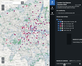
Managing extreme heat in cities by directing the public to places for heat stress relief and water sources.
Winter gardens: A brief history and warm variations

Extending the season with glass in different forms and terms.
Restoring Great Yarmouth's Winter Gardens

Transforming one of the least sustainable constructions imaginable.
Construction Skills Mission Board launch sector drive

Newly formed government and industry collaboration set strategy for recruiting an additional 100,000 construction workers a year.
New Architects Code comes into effect in September 2025
ARB Architects Code of Conduct and Practice available with ongoing consultation regarding guidance.
Welsh Skills Body (Medr) launches ambitious plan

The new skills body brings together funding and regulation of tertiary education and research for the devolved nation.
Paul Gandy FCIOB announced as next CIOB President

Former Tilbury Douglas CEO takes helm.
UK Infrastructure: A 10 Year Strategy. In brief with reactions

With the National Infrastructure and Service Transformation Authority (NISTA).

Ebenezer Howard: inventor of the garden city. Book review.
The Grenfell Tower fire, eight years on

A time to pause and reflect as Dubai tower block fire reported just before anniversary.
Airtightness Topic Guide BSRIA TG 27/2025
Explaining the basics of airtightness, what it is, why it's important, when it's required and how it's carried out.
Construction contract awards hit lowest point of 2025

Plummeting for second consecutive month, intensifying concerns for housing and infrastructure goals.
Understanding Mental Health in the Built Environment 2025

Examining the state of mental health in construction, shedding light on levels of stress, anxiety and depression.
Comments
[edit] To make a comment about this article, click 'Add a comment' above. Separate your comments from any existing comments by inserting a horizontal line.
Great explanation on what is Site plan.