


Surveying instruments
Contents |
[edit] Introduction
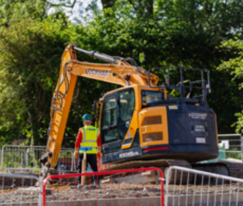
Surveying is the process and technique of determining distances and angles between points, used on construction sites for the purposes of levelling and setting out works.
Surveying relies for its accuracy and efficiency on having the right instruments. Surveyors use a range of instruments for land surveying and mapping, and setting out.
Historically, surveying equipment might have included:
- Chains with equal size links to measure distance between two points.
- Compasses to measure the direction of a line.
- Solar compasses to measure the direction and latitude of a particular point using the sun and stars.
- Dioptra to measure angles.
- Measuring wheels to measure large distances.
Modern surveying equipment might include:
[edit] Theodolite

Theodolites were developed to measure precise horizontal and vertical angles for the purpose of triangulation – determining the location and distance of a point through the formation of triangles.
In its simplest form, a theodolite consists of a moveable telescope attached over perpendicular axis. It is mounted on a tripod head by means of a tribarch containing thumbscrews for tightening and loosening. The theodolite should be placed vertically above the point to be measured using a plumb bob or laser plummet. Tubular spirit bubbles are used to keep the instrument level.
A ‘transit’ is a type of theodolite developed in the early-19th century by railroad engineers. As well as being able to turn horizontally, a transit has a vertical circle and a telescope that can be inverted in the vertical plane.
Modern theodolites use an electronic rotary encoder to read the horizontal and vertical circles to great levels of precision.
A gyro-theodolite comprises a gyroscope mounted to a theodolite and is used, predominantly in mine surveying and tunnel engineering, to determine the orientation of true north. Gyro-theodolites were used during the construction of the Channel Tunnel to align the two tunnels as they were constructed from both France and the UK.
A tachymeter (or tacheometer) is a type of theodolite used for rapid measurements. Similar to a rangefinder, it can determine electronically or electro-optically, the distance to a target.
[edit] Measuring wheel

Surveyors use measuring wheels for quicker and lower accuracy surveys of long distances by rolling it from the start to end point. Each revolution of the wheel measures a specific distance, such as a yard or metre. Counting revolutions with a mechanical device attached to the wheel measures the distance directly.
[edit] Dumpy level

A dumpy level consists of a telescope-like device fitted on a tripod stand and used for establishing or verifying points in the same horizontal plane. Together with a vertical staff, it is used to measure height differences and transfer elevations during building surveys.
Variants include:
- Tilting level: The telescope can be flipped through 180-degrees.
- Auto level or self-levelling level: Includes an internal compensator mechanism which automatically removes any variation when set close to level. This has the advantage of ease-of-use and can be set up quickly.
- Digital electronic level: This uses electronic laser methods to read a bar-coded vertical staff.
[edit] Tripod
Most surveying instruments are fixed on a tripod, which acts as a support. Tripods have three legs which can be extended or lowered as required.
[edit] Total station

A total station (sometimes referred to as a Total Station Theodolite TST) is a modern theodolite which is a transit fitted with an electronic distance meter (EDM).
A microprocessor unit in the total station processes the data collected to determine:
- The average of multiple angles measured.
- The average of multiple distance measured.
- The horizontal distance.
- The distance between any two points.
- The elevation of objects.
- All three coordinates of the observed points.
The data that is collected and processed can be downloaded for further processing by computer aided design (CAD), building information modelling (BIM) or geographic information system (GIS) software.
These are now the most commonly used surveying instrument due to their precision and accuracy. Total stations also enable field work to be carried out rapidly with quick calculations of coordinates.
[edit] Related articles on Designing Buildings
- Building survey.
- Condition survey.
- Construction tools.
- Geophysical survey.
- Global positioning systems and global navigation satellite systems.
- How to layout a building.
- Interview with David Southam about laser scanning in construction.
- Land surveying.
- Laser scanning.
- Level.
- Levelling.
- Plumb level.
- Real time kinematic RTK.
- Robotic total station.
- Site surveys.
- Surveyor.
- Tool and equipment care and maintenance.
Featured articles and news
Government consultations for the summer of 2025

A year of Labour, past and present consultations on the environment, the built environment, training and tax.
CMA competitiveness probe of major housing developers
![]()
100 million affordable housing contributions committed with further consultation published.
Homes England supports Greencore Homes

42 new build affordable sustainable homes in Oxfordshire.
Zero carbon social housing: unlocking brownfield potential

Seven ZEDpod strategies for brownfield housing success.
CIOB report; a blueprint for SDGs and the built environment

Pairing the Sustainable Development Goals with projects.
Types, tests, standards and fires relating to external cladding

Brief descriptions with an extensive list of fires for review.
Latest Build UK Building Safety Regime explainer published

Key elements in one short, now updated document.
UKGBC launch the UK Climate Resilience Roadmap

First guidance of its kind on direct climate impacts for the built environment and how it can adapt.
CLC Health, Safety and Wellbeing Strategy 2025

Launched by the Minister for Industry to look at fatalities on site, improving mental health and other issues.

One of the most impressive Victorian architects. Book review.
Common Assessment Standard now with building safety

New CAS update now includes mandatory building safety questions.
RTPI leader to become new CIOB Chief Executive Officer

Dr Victoria Hills MRTPI, FICE to take over after Caroline Gumble’s departure.
Social and affordable housing, a long term plan for delivery
The “Delivering a Decade of Renewal for Social and Affordable Housing” strategy sets out future path.
A change to adoptive architecture
Effects of global weather warming on architectural detailing, material choice and human interaction.

The proposed publicly owned and backed subsidiary of Homes England, to facilitate new homes.

How big is the problem and what can we do to mitigate the effects?
Overheating guidance and tools for building designers

A number of cool guides to help with the heat.
The UK's Modern Industrial Strategy: A 10 year plan

Previous consultation criticism, current key elements and general support with some persisting reservations.
Building Safety Regulator reforms

New roles, new staff and a new fast track service pave the way for a single construction regulator.
Comments