




Cooling centres, cool spaces and cool islands
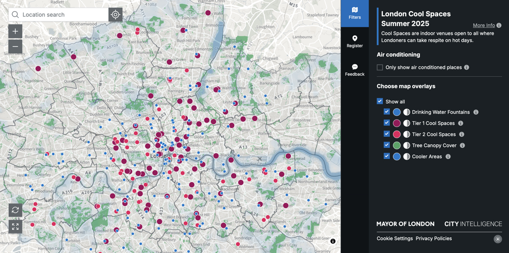
Cooling centres, also known as cool spaces, are locations across a city or region that are highlighted as places for members of the public to seek relief from the sun during a heat wave or extreme heat weather event.
Common in communities that suffer from extreme heat and extreme weather warnings, these centres may offer air conditioning and other resources such as water and food, acting as a refuge for those experiencing heat stress. These centres may offer a lifeline to vulnerable people or groups who maybe worst hit by heat, such as the elderly, infants and young children, people with chronic health conditions, pregnant women, and people with disabilities.
In London, the Cool Spaces app programme highlights indoor venues and outdoor spaces open to all members of the public where people can take respite on hot days. Indoor cool spaces were put forward by boroughs, community groups, faith-based and other organisations following an invitation to register by the Greater London Authority (GLA). These indoor Cool Spaces are then classified in two tiers:
- Tier 1 Cool Spaces - have lower temperatures than outdoors, free seating space for rest and recovery, free drinking water and toilets. They are accessible to disabled people, open at least five days a week and at least from 10am to 5pm.
- Tier 2 Cool Spaces - may not be accessible to disabled people, may not have toilets and may be open less frequently, but at least two days a week.
The tiered approach to classifying Cool Spaces is meant to provide Londoners with an understanding of what they can expect from venues and how some Cool Spaces can better suit their needs. The full criteria for the different tiers can be found here.
Parks and outdoor spaces that provide shade, shaded seating, drinking water and toilets are also signposted but may still be very hot.
The cool spaces map uses data from the following sources:
- Tree canopy cover: Data from London Tree Canopy Cover.
- Water fountains: Data from GLA Drinking Fountains Map.
- Basemap: Contains OS data © Crown copyright and database rights 2024.
For advice on staying safe in hot weather, read the Mayor’s guidance on keeping cool on hot days.
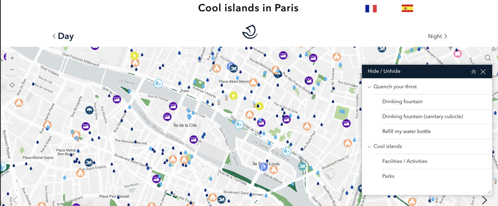
In Paris a similar approach referred to as Cool islands in Paris listing areas with water spray, permanent and temporary shading, public showers, swimming pools, air-conditioned library, oasis school yards, museum, places of worship and borough halls. It also indicated areas where vegetation over 8 metres covers up to 25%, 25-50% or over 50% of the ground area and areas where drinking facilities are available.
These mapping solutions have been developed hand-in hand with urban planning across the city with an increase in the use of Blue Green Infrastructure to help mitigate extreme weather patterns, with plans to plant 170,000 trees across the city by 2026. Other cities also plan extensive tree planting programmes to help tackle extreme weather and other benefits, such as Central Sydney in Australia, with extensive tree planting and Seville, Spain, along with increased awnings and what it calls its “policy of shade". Other models such as the green corridors which are shady routes through the city of Medellin in Colombia, or the Rotterdam Rooftop Walk initiative.which aims to add vegetation and greenery to some 900,000 square metres of rooftops across the city. All these initiatives can help create pockets in a city where extreme heat events can have a reduced impact on citizens and can be a lifeline for vulnerable people.
[edit] Related articles on Designing Buildings
- Adaptation.
- A shift in urban development priorities from brown to green with blue to red?
- Blue-green infrastructure.
- Climate.
- Climate change.
- Designing green and blue roofs.
- Disaster.
- Drought.
- Exceptionally adverse weather.
- Extraordinary weather event.
- Extreme weather.
- Extreme weather event.
- Extreme sea level.
- Flood.
- Future climate models.
- Global warming.
- How are buildings and their occupants responding to extreme heat?
- Weather.
Featured articles
Check out some of the best features and news from Designing Buildings as well as key stories from around the web.

Government approach could undermine delivery and regeneration.
World's first mass timber data centre.

The overlooked environmental aspect of data centre development.
Introduction to radon awareness

New technical information sheet published by CIOB.

Updated supplier guide can help electrical contractors engage with NHP.

CIAT confirm the winners of the 2026 architectural technology awards.
Government launches a one stop shop for flood preparedness.

Sir Edwin Lutyens: Britain's greatest architect? Book review.

CIOB publishes free template to help assess and manage risks.
ECA's reflections on Party Conference season

Burnham wants to be confident of winning before asking for a fresh mandate.
New Chief Construction and Scientific Adviser

Sergio Cavalaro, Professor of Infrastructure Systems at Loughborough University.
Building safety levy for England

CIAT publish estimator tool for members.
Water sector faces a growing crisis that could slow the delivery of vital infrastructure.