


Universal transverse mercator projection

Landsat is a joint mission of NASA and the U.S. Geological Survey (USGS) and is a part of the National Land Imaging (NLI) Program.
The Landsat glossary defines universal transverse mercator (UTM) projection as: “A widely used map projection that employs a series of identical projections around the world in the mid-latitude areas, each spanning six degrees of longitude and oriented to a meridian. This projection is characterised by its conformality; that is, it preserves angular relationships and scale and it easily allows a rectangular grid to be superimposed on it. Many worldwide topographic and planimetric maps at scales ranging between 1:24,000 and 1:250,000 use this projection.”
[edit] Related articles on Designing Buildings
Featured articles and news

Electrotechnical excellence, now open for entries.
Net zero electricity grids BSRIA guide NZG 5/2024
Outlining the changes needed to transition to net zero.
CIOB Global Student Challenge 2024

Universitas Indonesia wins for second year running.

New project and cultural district described in detail.
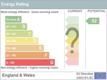
The nature of EPCs, crticism and inaccuracies.

History, issues and redesign.
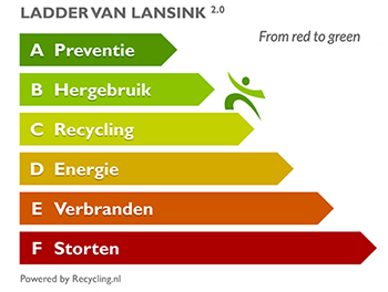
From waste recycling to energy performance the hierchy.
An introduction to WERCS and WEEE responsibilities

Dealing with 2 million tonnes of waste equipment a year.
Global BACS Market: analytics and optimisation

A BSRIA glance at building automation and control systems.

What it is and how to use it.

Types of insulating plaster by binder and insulant.
Investors in People: CIOB achieves gold

Reflecting a commitment to employees and members.

Scratching beneath the surface; a guide to selection.
ECA 2024 Apprentice of the Year Award

Entries open for submission until May 31.
UK gov apprenticeship funding from April 2024

Brief summary the policy paper updated in March.

For the World Autism Awareness Month of April.